At Large  September 3, 2024  Danielle Vander Horst

Rome’s Oldest Highway Added to the UNESCO World Heritage List

Wikimedia Commons, John Linton Chapman

John Linton Chapman (1839–1905), Via Appia, 1867. Oil on canvas, Georgia Museum of Art, University of Georgia. License

The old adage claims that all roads lead to Rome, and now, so too does the UNESCO World Heritage List. At the latest annual meeting of the World Heritage Committee, Italy's Via Appia (or ‘Appian Way’) joined 23 other cultural and natural sites on the UNESCO World Heritage List. 

The famous Roman road is not only historically and culturally significant, but it marks a unique milestone for Italy, making it the 60th World Heritage for the country— the most of any nation. 

Wikimedia Commons

A section of the Via Appia south of Rome and the ancient Aurelian walls. License

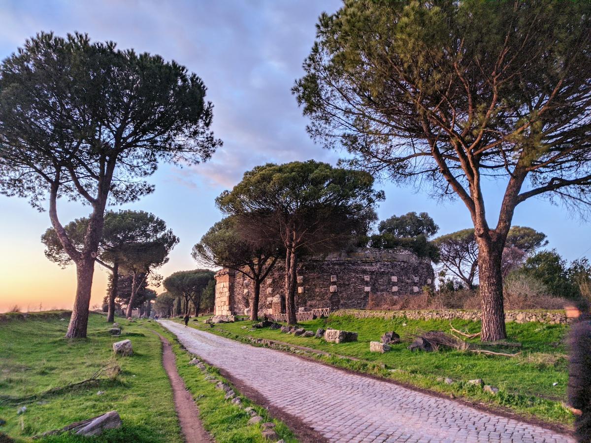
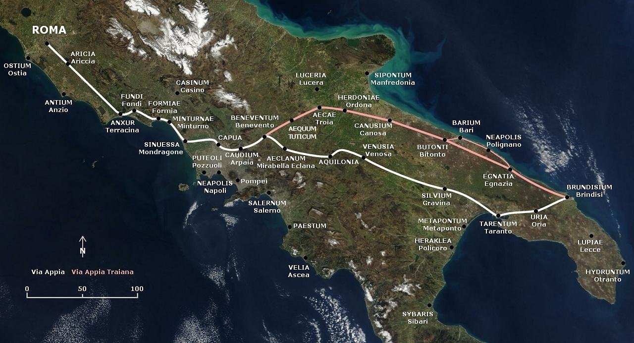
The road was originally conceived of as a military necessity for the Roman army around 312 BCE during the mid-Republican period when Roman expansionism and conquest was spreading into the furthest reaches of Italy. Running more than 800 kilometers from the heart of Rome to Brundisium (modern-day Brindisi) in the heel of the Italian peninsula, the Via Appia is not only the oldest Roman road, but it is also considered the most important. 

As a military route, the road enabled the swift and massive scale of the Roman army as it conquered southern Italy, improving the movement of troops and supplies, but also of critical information to and from Rome. In the years after conquest, the Via Appia facilitated a heightened level of connections between cities and settlements previously unseen on such a scale in Italy. 

Other intercity roads are known to have existed in Etruria— the territory of the Etruscans north of Rome— however, none compared to the impressive length and engineering mastery that the Romans had achieved with the Via Appia. 

Wikimedia Commons

A monumental column at Brundisium (modern day Brindisi) marks the end of the Via Appia just before the Adriatic Sea. License

The first iteration of the road began as little more than a leveled dirt road with stones and mortar laid on top, though more sophisticated engineering soon followed. A layer of gravel was later added onto the first level of stones and mortar, and finally atop the gravel were laid tightly fitted, interlocking stones to complete the flat, durable surface of the road. 

The construction was so precise that the historian Procopius, writing nearly 900 years after the road was first started, noted that the stones of the road were so perfectly fit together that they appeared to have grown into each other naturally, rather than having been fit together by human hands. Even more impressively, the entire length of the road was cambered in the middle with ditches and retaining walls on either side to allow for water runoff. 

Wikimedia Commons

A section of the Via Appia now within the Appian Way Regional Park outside of Rome. The road is accessible to walkers and bicyclists and runs past many Roman archaeological ruins. License

Over the years, the Via Appia acted as a main artery of the Roman world in southern Italy with many Roman cities and monuments springing up around it. Closer to the city of Rome, many impressive tombs were constructed by the city’s elite and wealthy, while further along the road stretching all the way to Brundisium, several bridges, triumphal arches, baths, amphitheaters, aqueducts, canals, and public fountains were built. 

Many pivotal historical events also took place along or on the road, including the crucifixion of Spartacus’ army in 71 BCE, countless battles during the Roman conquest of the south, and even the 1960s Olympics which used part of the road for the men’s marathon course that year. 

Wikimedia Commons

The Via Appia, in white, runs from Rome in central Italy down to Brundisium (modern day Brindisi) in the heel of the Italian peninsula. A secondary deviation of the road, marked in red, was constructed under the emperor Trajan in 109 CE. License

Though many parts of the road largely fell out of use after the 4th century CE, the vast majority of it has survived to this day and it continues to hold claim to having Europe’s longest stretch of straight road at 62 kilometers. 

In some areas, the Via Appia has even been incorporated into modern traffic patterns, while in other stretches, it has been restored and preserved for public use as bike and walking paths. One large swath of the road is now part of the Appian Way Regional Park, the second largest urban park in Europe covering 4580 acres of nature and archaeological remains

About the Author

Danielle Vander Horst

Dani is a freelance artist, writer, and archaeologist. Her research specialty focuses on religion in the Roman Northwest, but she has formal training more broadly in Roman art, architecture, materiality, and history. Her other interests lie in archaeological theory and public education/reception of the ancient world. She holds multiple degrees in Classical Archaeology from the University of Rochester, Cornell University, and Duke University.

Subscribe to our free e-letter!

Webform
Art and Object Marketplace - A Curated Art Marketplace